This week we’re at the Esri Arc GIS User Conference in San Diego. There are over 15,000 people at this conference every year and it’s 1 of the bigger conferences we go to, as well as a great opportunity to meet a lot of customers in person. We’re in the Esri Emerging Business Partner Program and we’ve been heavily integrated with Esri for years as our premier map provider.
Stop by our booth, Z25, and check out some of the latest features we’ve added to Tools.Valarm.net:
- ArcGIS.com Named User Identities – Link your Industrial IoT Sensor Information with your ArcGIS Online Account and Data!
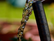
- Esri 3D Mapping – Visualize your sensor data on a 3D globe for a spectacular experience with colorful spikes for your sensor data. This makes it easy to spot patterns and trends in your remote assets that are monitoring anything, like air quality or water.
 Curious about what our industrial customers are doing with Valarm around the world?
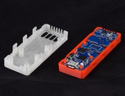
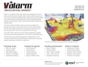
Have a gander at our Industrial IoT / Remote Monitoring Customer Success Stories page for more info on how various industries use Tools.Valarm.net for remotely monitoring sensors made by any hardware manufacturer like:
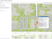
How do you visualize and alert based off your remote asset’s current sensor conditions? Take a look at our Web Dashboards for remotely monitoring Industrial IoT GPS-tagged sensors in real-time.
Your dashboards include maps, graphs, email alerts, and other widgets you can use and view on any device with a web browser, like your phone or tablet.
Please don’t hesitate to contact us at Info@Valarm.net if you’ve got any questions!